
BOULDER VIEW FIRE
UPDATE 6/29/24
#BoulderViewFire Sat. 6/29/2024 Update:
3,736 ac. w/no containment. Today, fire crews cont. efforts toward full suppression by improving firelines & monitoring for any heat w/n interior of the fire. Crews made good progress on the slop over on N side & will cont. working that piece today ensuring there’s no heat remaining.
S. side of fire conts. to hold & checked itself up on 2-track road. No heat showing yesterday & today will cont. to be monitored for any possibility of lingering heat.
SE side still active & holding a lot of heat. Hand crews engaged and if necessary helos will support w/bucket work for lingering hotspots.
At this time, GO/SET remain in place. All info in regards to evac & pre-evac statuses will come from maricopa.gov.
Bartlett Dam Road at Cave Creek Road remains closed to the public.
Add’l fire info:
inciweb.wildfire.gov/inci…/aza4s-…
#AZFire #AZForestry @TontoForest
Update 6/10/24
Adams Fire final update; Tonto National Forest takes command 06-10-2024
Publication Type: News – 06/10/2024 – 07:00
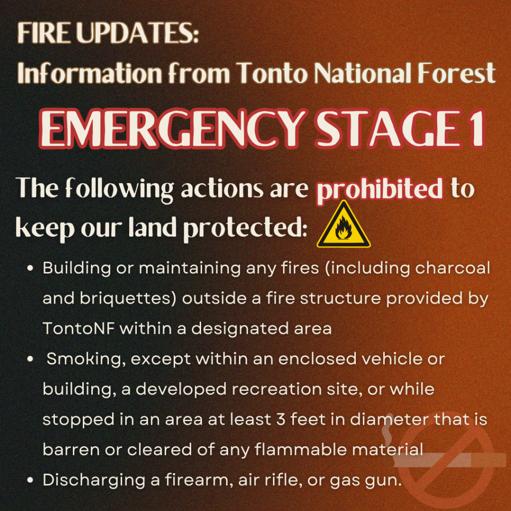
Highlights: The Central West Zone Incident Management Team will transfer command of the Adams Fire to the Tonto National Forest at 6 p.m. This will be the final update produced by the Team. For future information about the Adams Fire, contact the Tonto National Forest. There are still smoldering fuels within the fire area and smoke will likely be visible in the coming days. Stage 1 Fire Restrictions are in effect for the Tonto, Coconino, and Apache-Sitgreaves National Forest, as well as other jurisdictions. Fire Restrictions Map for Arizona and New Mexico: https://wildlandfire.az.gov/fire-restrictions
Operations: Yesterday, fire crews identified lingering heat and mopped up the northwest portion of the fire area, specifically in a thick mesquite bosque. Crews also repaired fences and trails that were used for accessing the fire during initial attack. Fire crews working on the Adams Fire are prepared to support the Tonto National Forest with any new wildfire starts if necessary.
Weather: Temperatures will stay hot today, with highs of 105 degrees. Fuel moisture is critically low, and fuels are very receptive to fire. Winds will be calm in the morning and from the west in the afternoon.
Closures: Closure orders are in effect in the Tonto National Forest surrounding the Adams Fire. View the current closure order and Stage 1 fire restrictions here: https://www.fs.usda.gov/alerts/tonto/alerts-notices/?aid=87846
Safety: The health and safety of firefighters and the public are always the highest priority. Please avoid the area while crews conduct fire suppression operations. Citizens are urged to sign up for the Maricopa County Emergency Notification System. The system allows you to be quickly notified of emergency evacuations. To learn more about the Arizona Emergency Information Network visit: https://ein.az.gov/ready-set-go. Firefighting aircraft and drones are a dangerous combination. Drones in the area could lead to accidents or slow down wildfire suppression operations. If you fly…we can’t.
Smoke: Smoke from the Adams Fire has decreased; however, it may be visible in the surrounding areas for many days. Smoke will drift to the north and east due to prevailing winds. Individuals who are sensitive to smoke or have conditions aggravated by smoke are encouraged to take precautionary measures. An interactive smoke map at https://fire.airnow.gov/ allows you to zoom into your area to see the latest smoke conditions.
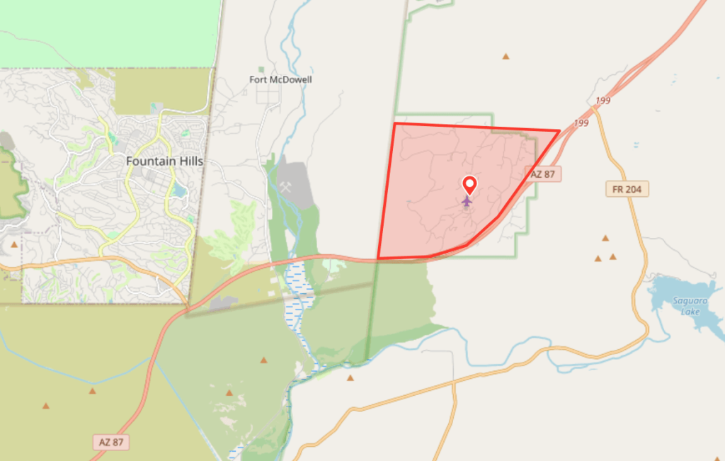
Location: 1 mile east of Fort McDowell, AZ
Start Date: June 2, 2024
Size: Approximately 5,029 acres
Percent Contained: 100%
Cause: Human
Vegetation: The fire is smoldering grass and brush.
Resources: 1 Type-2 Handcrew, 2 Helicopters, 7 Engines, and 2 Water Tenders.
Number of Personnel Assigned: 124
View wildfire statistics at Tonto National Forest’s fire dashboard.
Tonto National Forest: https://www.fs.usda.gov/main/tonto/fire
InciWeb: Adams Fire Fire email: 2024.adams@firenet.gov Information Phone: 928-275-8205
Social Media: Instagram @tontonationalforest, X @TontoForest and Facebook @TontoNationalForest
UPDATE: 6/5/24
UPDATE: 6/4/24
| Acres: Approximately 5,029 | Start date: June 2, 2024 |
| Cause: Under Investigation | Location: 1 mile east of Fort McDowell, AZ |
| Containment: 30% | Vegetation: Grass and brush |
| Total personnel: 249 | Resources: (5) Type 1 handcrews, (1) Type 2 handcrew, (1) Type 3 Helicopter, (4) Type 3 Engines, (14) Type 6 Engines, and (2) Water Tenders |
Highlights: The Central West Zone Type 3 Incident Management Team took control of the Adams Fire at 7 a.m. on June 4. Yesterday morning, firefighters were able to burn out control lines and held the fire within its footprint throughout the day. Today, firefighters will continue to monitor and patrol control lines and mop up. There is still high fire danger throughout the Tonto National Forest and multiple other active fires such as the Spring Fire and Catahoula Fire.
Operations: Firefighters will continue strengthening and mopping up control lines. Mop up describes the hard physical labor process of extinguishing or removing burning material near control lines down to the mineral soil, felling damaged trees and cooling ash pits to make a fire line less likely to escape. Additional resources will be arriving to the fire today, including additional engines, UTV’s, and medical support.
Weather: The weather will continue to be hot and dry around the fire area, with highs over 100 degrees and humidity dropping to single digits. Winds will be light and coming from the east.
Closures: There are closure orders in effect on the Tonto National Forest for the Adams and Spring Fires, as well as Emergency Stage 1 Fire Restrictions. Stage 1 Fire Restrictions will be in place across the entire forest Thursday, June 6. The latest closures and restrictions are available on the Tonto’s website at: https://www.fs.usda.gov/alerts/tonto/alerts-notices/?aid=87846
Safety: The health and safety of firefighters and the public are always the highest priority. Please avoid the area while crews conduct fire suppression. Citizens are urged to sign up for the Maricopa County Emergency Notification System. The system allows you to be quickly notified of emergency evacuations. To learn more about the Arizona Emergency Information Network visit: https://ein.az.gov/ready-set-go. Firefighting aircraft and drones are a dangerous combination. Drones in the area could lead to accidents or slow down wildfire suppression operations. If you fly…we can’t.
Smoke: Smoke from the Adams Fire has recently decreased; however it may be visible in the surrounding areas for many days. Smoke will drift to the north and east due to prevailing winds. Individuals who are sensitive to smoke and people with heart disease are encouraged to take precautionary measures. An interactive smoke map at https://fire.airnow.gov/ allows you to zoom into your area to see the latest smoke conditions.
Information Links and Contacts:
Tonto National Forest: https://www.fs.usda.gov/main/tonto/fire
InciWeb: Adams Fire Fire email: 2024.adams@firenet.gov Information Phone: 928-275-8205
UPDATE: 6/3/24
BLM implements seasonal fire restrictions in central and western Arizona due to increased fire risk
PHOENIX – Effective Thursday, June 6, at 8 a.m. seasonal Stage 1 fire restrictions will be implemented on Bureau of Land Management-managed lands in the Colorado River District and Phoenix District. This includes BLM-managed lands in La Paz, Maricopa, southern Mohave, northern Pinal, western Pima, Yavapai and Yuma counties. Fire managers have noted an increase in wildfire activity, which is anticipated to peak as the weather continues to get hotter and drier in the coming months. Fire restrictions help to limit activities on public lands that are known to be the most common causes of wildfires.
Beginning Thursday, June 6, at 8 a.m., these activities are prohibited:
- Building, maintaining, attending, or using a fire, campfire, charcoal, coal, or wood stove fire, except within a developed recreation site, or improved site.
- Smoking, except within an enclosed vehicle or building. Smoking is prohibited in all federal buildings.
- Discharging a firearm, air rifle or gas gun, except while engaged in a lawful hunt pursuant to state, federal, or tribal law, and regulations.
- This restriction also includes the Phoenix District’s developed recreational shooting sites: Baldy Mountain, Box Canyon, Church Camp Road, and Saddleback Mountain.
- Welding or the use of any torch or metal cutting or grinding implement.
Fireworks and exploding targets are prohibited year-round on federally managed lands in Arizona.
Pressurized liquid or gas stoves, lanterns and heaters possessing shut-off devices are allowed. When using a portable stove, make sure the area is clear of grass and other vegetation and on a stable surface to prevent stoves from tipping and starting a fire.
Residents and visitors should check with respective county and municipal governments for information on fire restrictions in those jurisdictions.
Fire conditions as well as localized closures and restrictions are subject to change. Tribal, federal, state, and local mandates are different, they may have some differences in their restriction notices. Variations are possible, and visitors should check with the most local office for area-specific restrictions and regulations.
Violation of restrictions is punishable by fine, imprisonment or both. Violators may also be held personally responsible for reimbursement of fire suppression costs.
To further help to prevent wildfires, never throw cigarettes out of a vehicle window. Use an ashtray instead. Never park a vehicle over dry grass as the underside of a vehicle can get hot enough to ignite the vegetation. Make sure your vehicle is in good operating condition, tires are well inflated, and check for any dragging metal or chains from towed trailers.
For a more detailed explanation concerning agency restrictions and fire information in general, please contact the nearest land management agency office where you plan to work or play or visit https://wildlandfire.az.gov.
Additional Useful Links/Resources:
Fire Restrictions Map for Arizona and New Mexico: https://wildlandfire.az.gov/fire-restrictions
Use this Interactive Map to help determine who manages the lands where you plan to recreate.
-BLM-
The BLM manages more than 245 million acres of public land located primarily in 12 western states, including Alaska, on behalf of the American people. The BLM also administers 700 million acres of sub-surface mineral estate throughout the nation. Our mission is to sustain the health, diversity, and productivity of America’s public lands for the use and enjoyment of present and future generations.
Adams Fire
On Sunday, June, 2024 at 5:20 p.m. Forest Service fire personnel were dispatched to the Lower Sycamore area off State Route 87 near mile marker 200 in response to a reported wildfire. The initial attack included multiple engines, air attack,1 helicopter and 2 super scooper.
Today, June 3, 2024: Resources responding: 17 engines, interagency hotshot crews, Mesa Medic.
Aviation resources ordered or on scene: air attack, 2 VLATS, 1 heavy helicopter, 1 light helicopter, 2 Super Scoopers.
Type 3 Central West Zone Team has been ordered. An in-briefing will be held this afternoon.
Agencies on scene: Fort McDowell Bureau of Indian Affairs, Tonto National Forest and Department of Forestry and Fire Management.
Super Scooper aircrafts will be picking up water from local Reservoir Lakes. Please exercise caution and stay clear of the area where they are scooping. Please avoid the Lower Sycamore area during fire suppression operations.
Authorities warn residents near Adams Fire north of Mesa about potential evacuations
Jun 3, 2024, 11:21 AM | Updated: 11:36 am
BY KTAR.COM
PHOENIX — Authorities warned residents near the Adams Fire north of Mesa about the potential for evacuations on Monday morning.
The Goldfield Ranch community north of State Route 87, about 8 miles east of Fountain Hills, was placed in the SET status of the state’s emergency alert system, meaning there is significant danger in the area.
UPDATE: 5/30/24
Wildcat Fire
Updated May 29
- Location: West of Bartlett Lake
- Start date: May 18
- Size: 14,402 acres
- Containment: 86%
- Fuels involved: Short grass, brush
- Cause: Human
- Total personnel: 19
- Cost: $420,000
UPDATE: 5/22/24
UPDATE: 5/21/24
Firefighters gain some containment of Wildcat Fire burning north of Phoenix
May 21, 2024 | 3:03 AM
PHOENIX — Firefighters had a breakthrough Monday in containing the Wildcat Fire that has been burning north of Phoenix for days.
The blaze was 23% contained as of 6:30 p.m., according to the Tonto National Forest. An update shared earlier Monday had no containment on the fire that has grown to more than 14,000 acres.
Fire managers aren’t expecting much growth or movement on the fire over the next day due to favorable weather conditions.
The blaze is burning about 30 miles northeast of Phoenix near Cave Creek.
Timeline of the Wildcat Fire
The fire, which officials say was human-caused, was first reported at Saturday around 9:20 a.m.
Within a day, the blaze grew to 5,000 acres.
Closure orders in the Cave Creek Ranger District were issued Saturday and expanded Monday as a result of the fire’s growth. Bartlett Dam Road has been closed since 3:30 p.m. Saturday due to the blaze.
About 300 personnel are working the blaze, including eight crews, 16 fire engines, three helicopters and two water tenders.
There were no immediate threats to structures and evacuations were not planned.
The public was asked to stay away from the area until the fire is contained.
UPDATE: 5/20/24
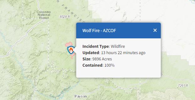
Wolf Fire operations wrap up following 10,000 acres of forest treatment
Coconino National Forest to continue holding fire perimeter
HAPPY JACK, Ariz., May 13, 2024 — Wolf Fire operations have resulted in the treatment of roughly 10,000 acres of land following a late April lightning strike on the Coconino National Forest’s Mogollon Rim Ranger District.
Fire managers spent roughly one week conducting firing operations to reduce dead vegetation and hazardous fuels, restore critical nearby watersheds, improve wildlife habitat and lessen the future risk of catastrophic wildfire in the Clints Well area.
“We’ve had really good fire effects with west winds pushing in over the last few days,” said Incident Commander (Trainee) Paul Oltrogge. “The weekend’s light rains moderated things nicely, and the effects of the Wolf Fire are already looking incredibly beneficial for the landscape.”
Firing operations wrapped up in advance of heavier predicted rains on Tuesday and Wednesday.
The Northern Arizona Type 3 Incident Management Team, which has been managing the Wolf Fire since May 6, plans to transition management of the fire back to the Coconino National Forest on Wednesday.
A closure order remains in place for the area surrounding the fire, as does a temporary flight restriction. Drone and aircraft operators are asked to abide by the issued restrictions.
Forest visitors can check the Coconino National Forest’s website at coconinonationalforest.us for updates regarding fire area closures.
There are roughly 150 personnel assigned to the 9,896-acre Wolf Fire, including two Hotshot crews, nine engines, one dozer, two water tenders and one hand crew.
Lightning-caused fires allow an opportunity for land treatment: The removal of forest fuels – such as pine needle accumulation, dead and down trees and other dry plant matter – that create hazardous conditions that could lead to potential catastrophic wildfire.
Land treatment using fire is an important part of the Forest Service’s 10-year Wildfire Crisis Strategy, which aims to reduce the risk of wildfire to critical infrastructure and communities.
As part of the overall Wildfire Crisis Strategy, the Coconino National Forest is committed to restoring land and protecting watersheds – including work on the Cragin Watershed Protection Project – as part of the wider Four Forest Restoration Initiative (4FRI).
This is the last scheduled news release regarding the Wolf Fire. For continued updates on the Wolf Fire, please visit inciweb.wildfire.gov, where fire updates will be posted until full fire containment.

Please click here for an interactive NWCG Wildfire Situational Awareness Map.
Arizona County Emergency Notification Systems – Sign up for Emergency Notifications for your county/community.
Click here to find more resources regarding wildfire preparedness.